Wer hat denn hier gemalt?

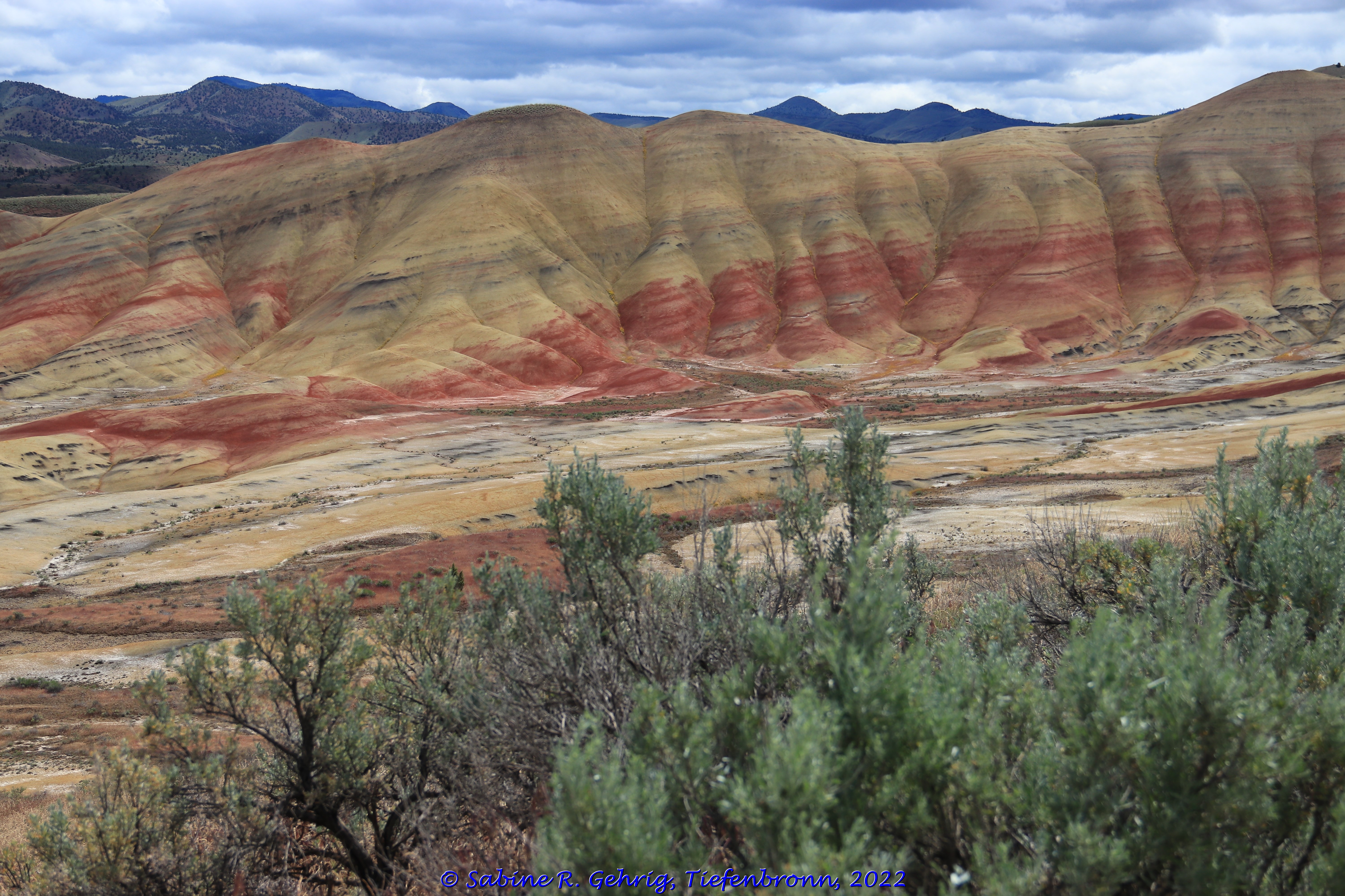
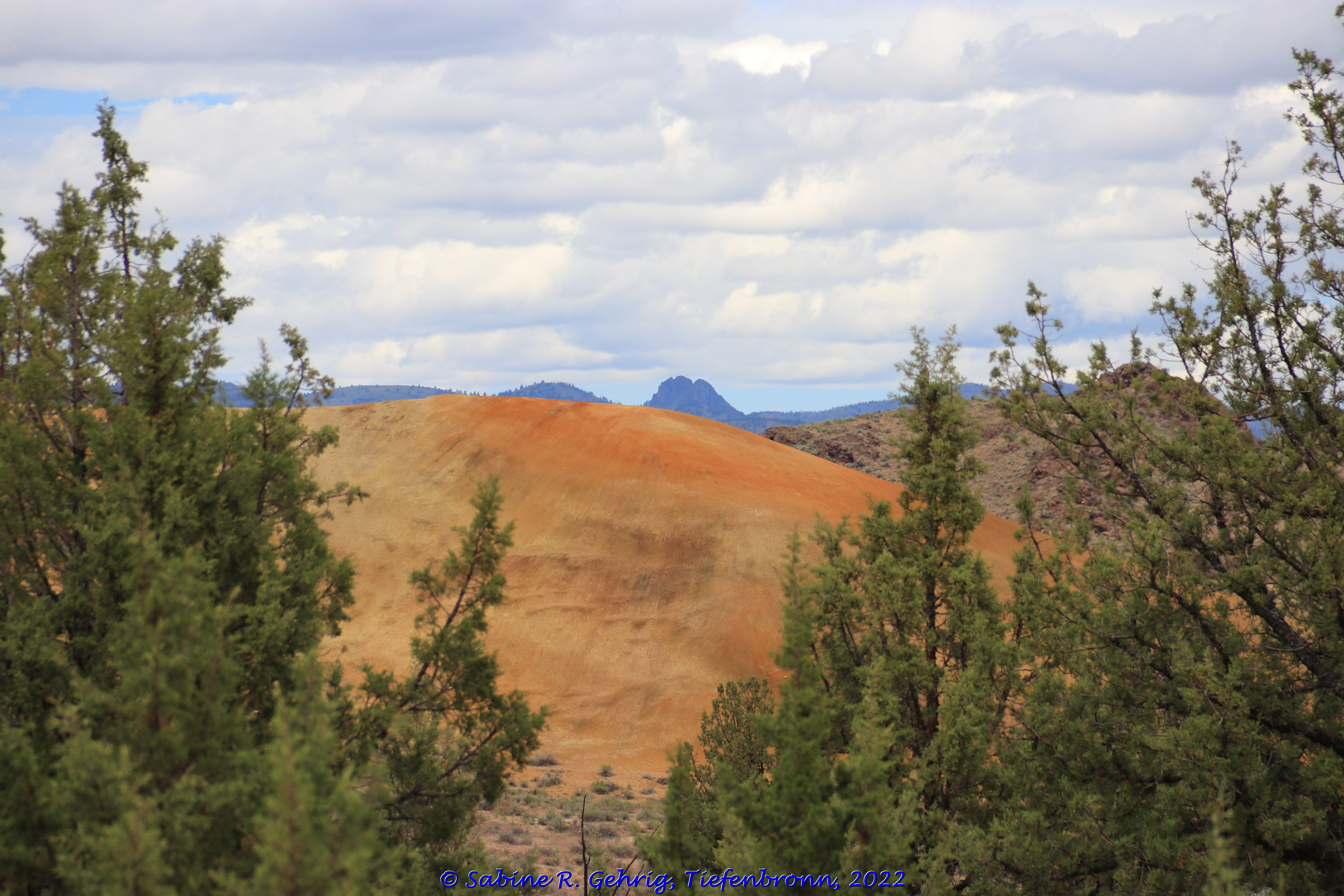
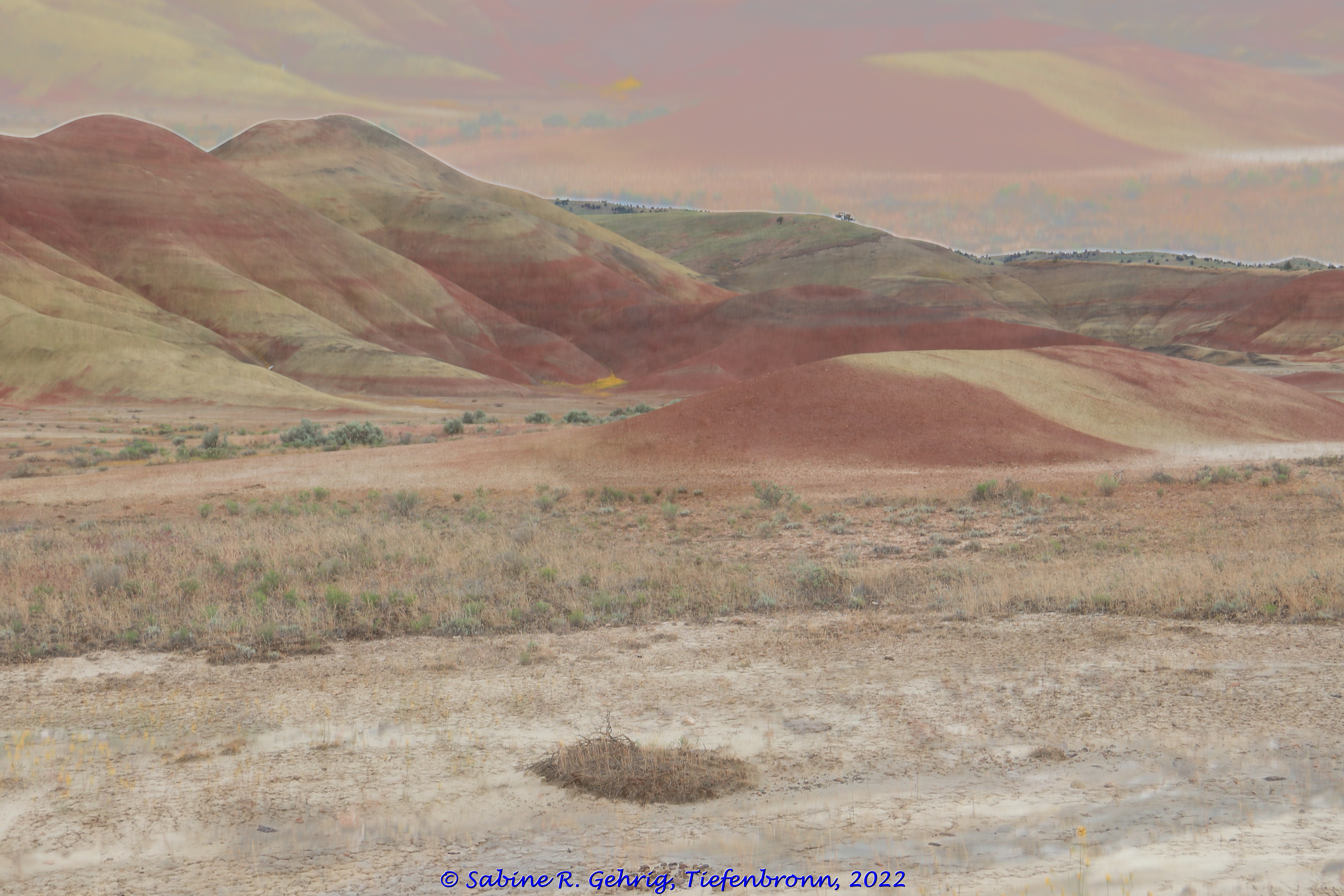
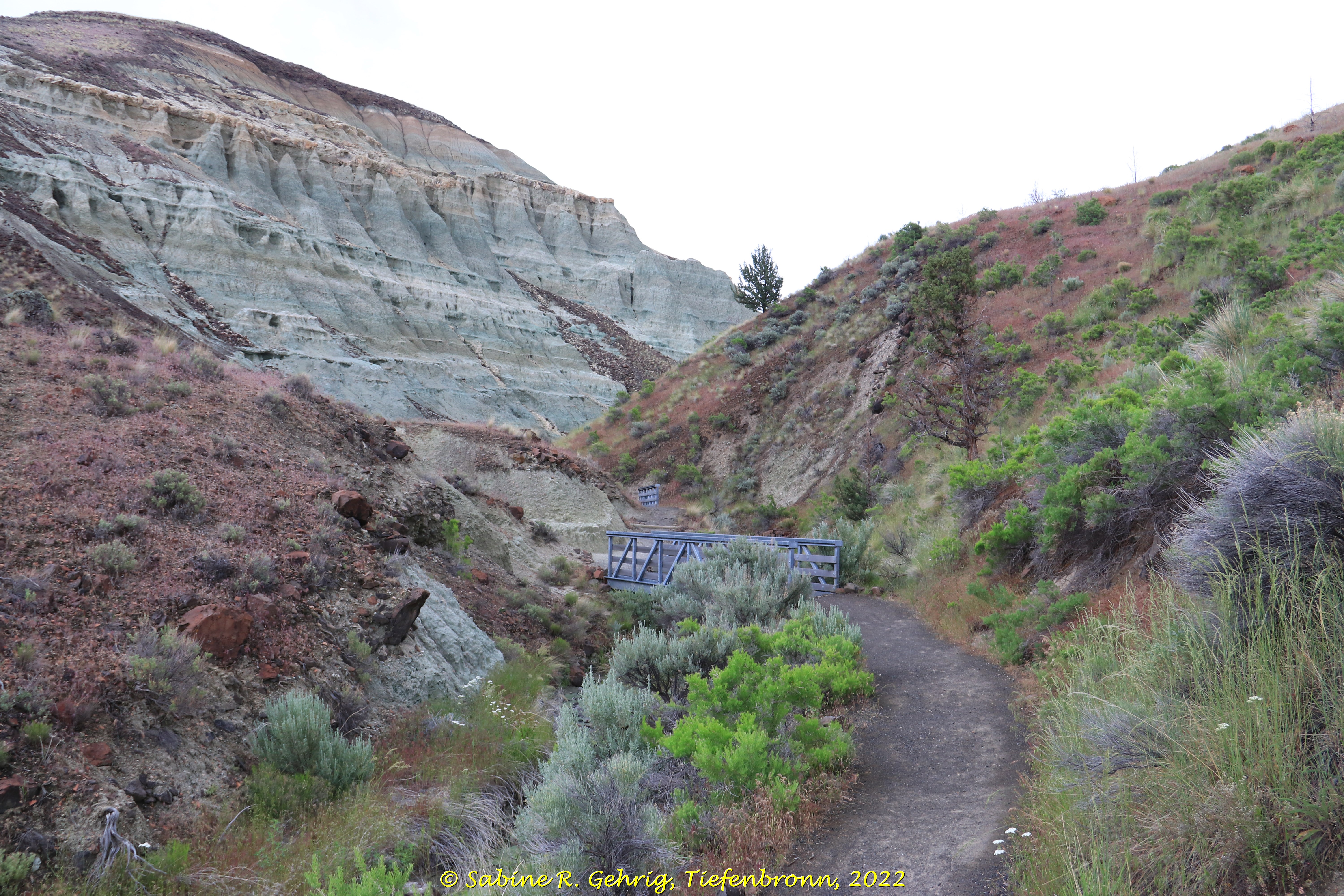
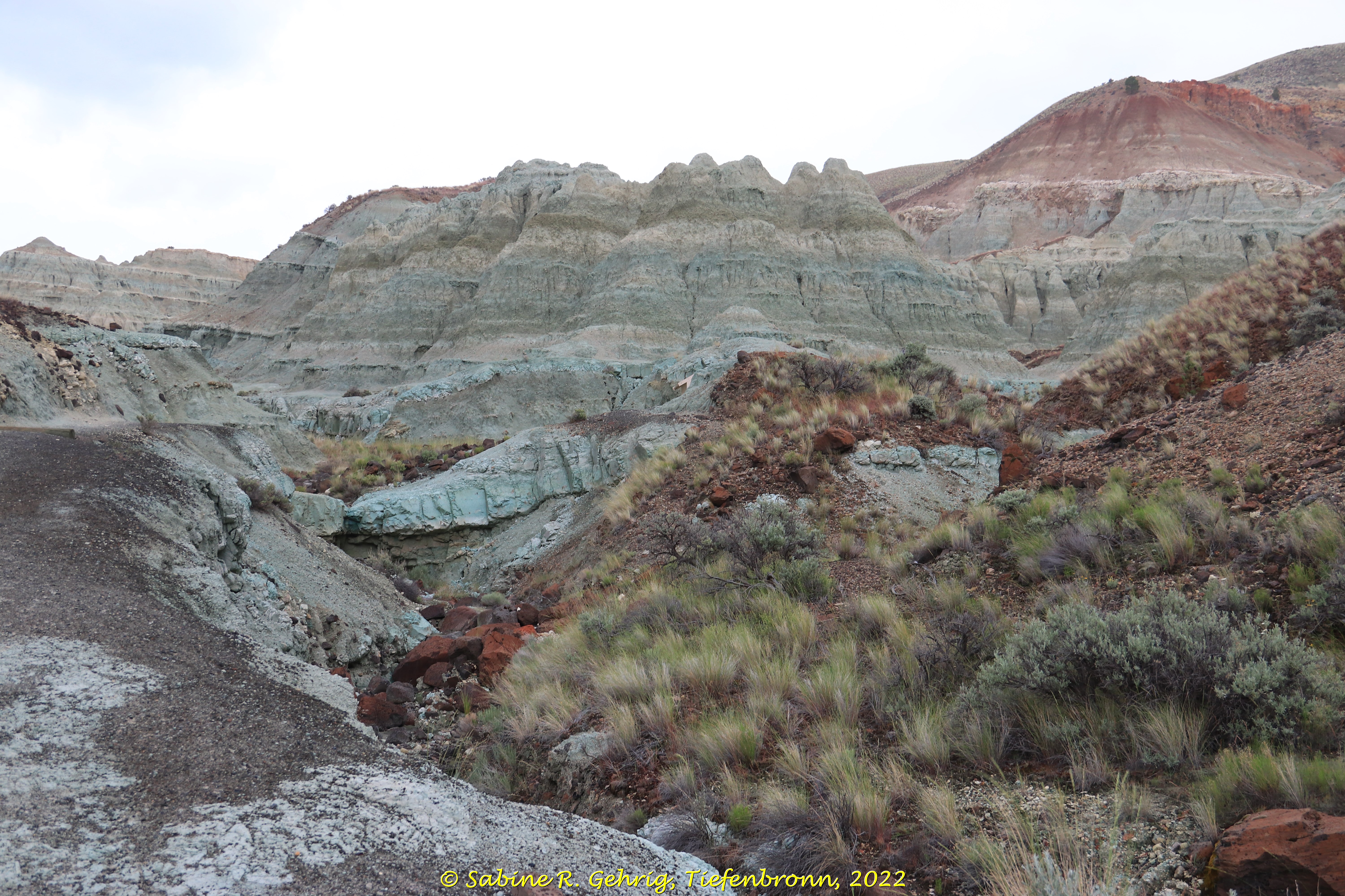
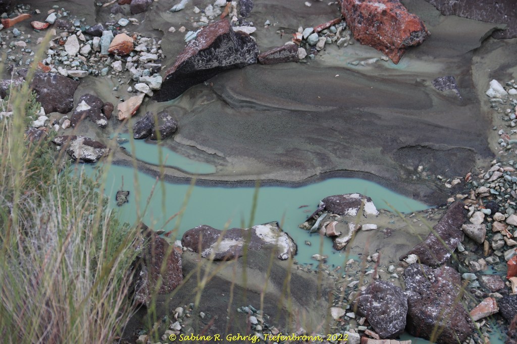
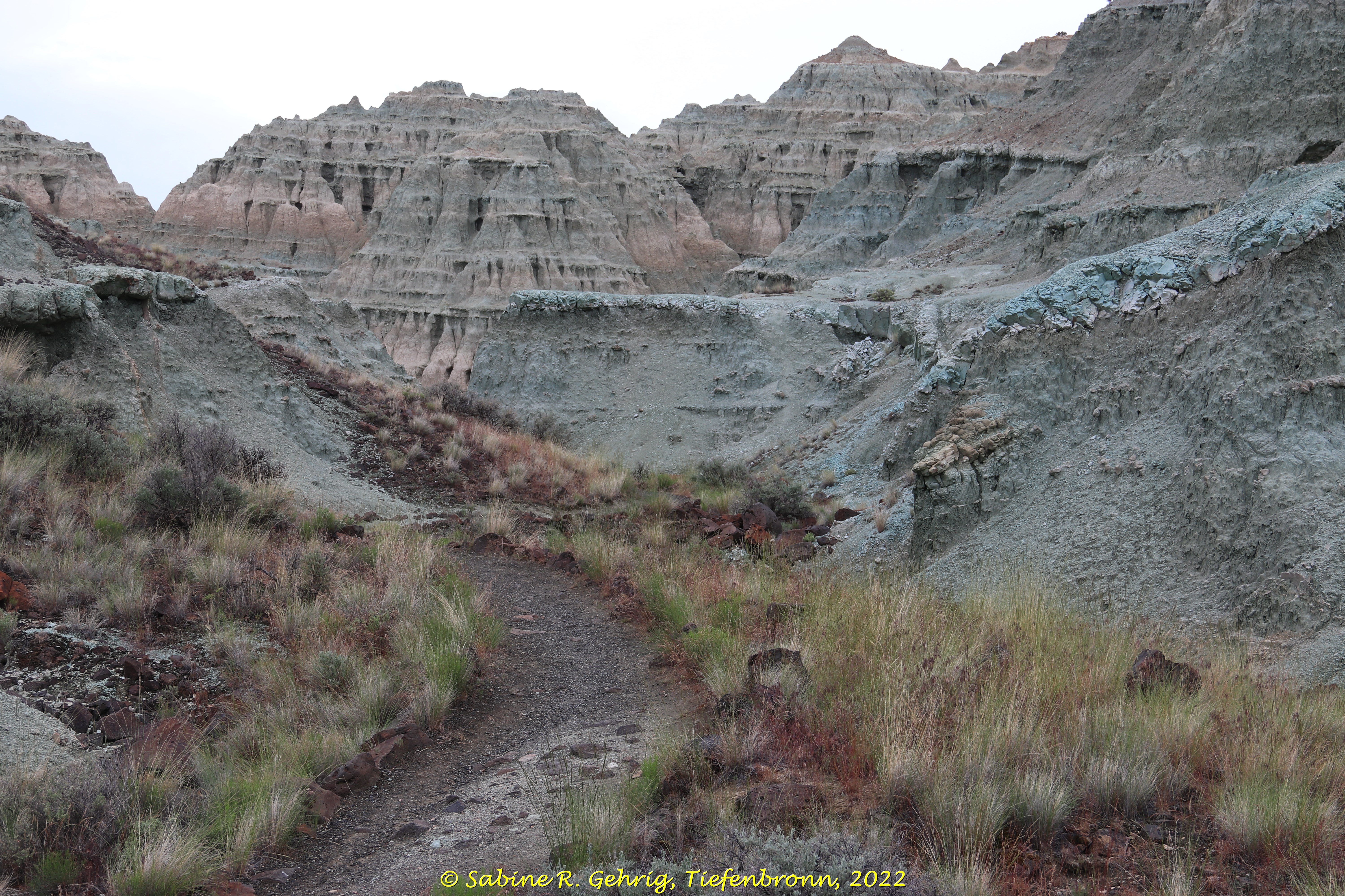
Die Natur und zwar schon vor langer Zeit. Die Farben spiegeln die klimatischen Veränderungen in der Zeit von 34 bis 28 Millionen Jahren wider, nachdem vor 35 Millionen Jahren jede Menge Asche von den Vulkanen der Cascade Mountains hier abgelagert wurde. Durch verschiedene Prozesse wurde mit der Zeit Stein daraus. Während es zu Beginn dieser Zeit noch tropisch feucht war, entstanden die rötlichen Farbtöne. Als es dann kühler und trockener wurde, entstanden die gelblichen und bräunlichen Töne. Alle Schichten enthalten zahlreiche Mineralien und Fossilien. Der dunkle, schwarze Boden ist Braunkohle; graue Farben kommen z. B. vom Schlamm- und Schiefergestein und schwarze Flecken sind auf Manganoxid zurückzuführen. Und wo liegen diese Gemälde? In der Painted Hills Unit des John Day Fossil Beds National Monument in Oregon.

English Summary

Who Has Painted Here?

Nature, and a long time ago. The colors reflect the climatic changes in the period from 34 to 28 million years ago, after a lot of ash from the volcanoes of the Cascade Mountains was deposited here 35 million years ago. Through various processes over time, the ash turned into stone. While it was still tropically humid at the beginning of this time, the reddish hues developed. Then, as it became cooler and drier, the yellowish and brownish tones developed. All layers contain numerous minerals and fossils. The dark, black soil is lignite; gray colors come from mudstone and shale, for example, and black stains are due to manganese oxide. And where are these paintings located? In the Painted Hills Unit of the John Day Fossil Beds National Monument in Oregon.

John Day Fossil Beds National Monument, Oregon, USA – Blick auf die Painted Hills / View of the Painted Hills
John Day Fossil Beds National Monument, Oregon, USA – nicht nur die Hügel sind ‚angemalt‘, die Gräser, Büsche und Blumen können farblich mithalten / not only the hills are ‚painted‘, the grasses, bushes and flowers can keep up in color
John Day Fossil Beds National Monument, Oregon, USA – bunte Farben entlang des Painted Cove Trail; der lavendel-graue Stein im Vordergrund sind die stark verwitterten Überreste eines rhyolitischen Lavastroms / bright colors along the Painted Cove Trail; the lavender-gray rock in the foreground is the heavily weathered remains of a rhyolitic lava flow
John Day Fossil Beds National Monument, Oregon, USA – eine Schlange am Wegesrand / a snake on the wayside
John Day Fossil Beds National Monument, Oregon, USA – ein gelber Hügel gesehen vom Leaf Hill Trail aus / a yellow hill seen from the Leaf Hill Trail
John Day Fossil Beds National Monument, Oregon, USA – die gelbe Rückseite des Red Scar Knoll / the yellow back of the Red Scar Knoll
John Day Fossil Beds National Monument, Oregon, USA – und die namensgebende rote Vorderseite des Red Scar Knoll / and the namesake red front of the Red Scar Knoll
John Day Fossil Beds National Monument, Oregon, USA – ein letzter Blick auf die ‚bemalten Hügel‘ / a last look at the Painted Hills

Über 13 Brücken…

… musste ich gehen, um ins Blue Basin zu kommen. Und das war nicht blau, sondern mehr grünlich-grau. Aber wo befindet sich das ‚blaue Becken‘? Im John Day Fossil Beds National Monument in Oregon, wo es wolkig war und zwischendurch sogar leicht geregnet hat. Das National Monument ist ein Paradies für Freunde der Geologie. Diese Formation besteht aus versteinerter Asche, die Vulkane vor ca. 30 Mio. Jahren ausgestoßen haben und die hier abgelagert wurde und Tiere und Pflanzen begraben hat – denn sonst würde man heute nicht über 100 verschiedene Fossilien hier finden.

English Summary

13 bridges…

… I had to cross to get to the Blue Basin. And it was not blue, but more greenish-grey. Where is the ‚blue basin‘ located? In John Day Fossil Beds National Monument in Oregon, where it was cloudy when I visited and even rained lightly in between. The National Monument is a paradise for friends of geology. This formation consists of petrified ash that volcanoes ejected about 30 million years ago and which was deposited here and buried animals and plants – otherwise you wouldn’t find over 100 different fossils here today.

John Day Fossil Beds National Monument, Sheep Rock Unit, Oregon, USA – die 2. und 3. Brücke auf dem Weg ins Blue Basin und der Fels links gibt schon einen Vorgeschmack / the 2nd and 3rd bridge on the way to Blue Basin and the rock on the left gives already a foretaste
John Day Fossil Beds National Monument, Sheep Rock Unit, Oregon, USA – Felswände aus vor Millionen von Jahre abgelagerter Asche begleiten mich / Rock walls of ash deposited millions of years ago accompany me
John Day Fossil Beds National Monument, Sheep Rock Unit, Oregon, USA – Pfützen im Bachlauf, der das Blue Basin verlässt und das Wasser grünlich färbt / Puddles in the creek leaving the Blue Basin and turning the water a greenish color
John Day Fossil Beds National Monument, Sheep Rock Unit, Oregon, USA – Blick ins Amphitheater mit seinen markanten, nicht ganz blauen Felsen / View into the amphitheater with its striking, not quite blue rocks
John Day Fossil Beds National Monument, Sheep Rock Unit, Oregon, USA – eine der 13 Brücken, über die ich auch wieder zurückgehen musste / one of the 13 bridges I also had to cross on my way back
John Day Fossil Beds National Monument, Sheep Rock Unit, Oregon, USA – und nochmal ein Blick zurück auf die ein bisschen blauen Felsen, ok mit etwas Fantasie / and again a view back to the rocks looking a little bit blue, ok with some imagination

Der unsichtbare Graben

Eigentlich wollte ich an eine Stelle, an der der Graben sichtbar ist. Ok – es ist kein Graben so wie wir uns das vielleicht vorstellen. Es ist die Stelle, an der zwei große Kontinentalplatten zusammentreffen – die nordamerikanische und die pazifische Platte, und zu dieser Verwerfung führen, dem San Andreas Graben. Im Carrizo Plain National Monument in Zentralkalifornien gibt es eine Stelle, wo man das gut sehen kann. Im Jahr meines Besuchs (2018) kam der Frühjahrsregen leider sehr spät, so dass ich mit meinem Pkw nicht dahin fahren konnte. Und so seht Ihr einige Bilder des Carrizo Plain und eben den unsichtbaren Graben.

English Summary

The Invisible Fault

Actually, I wanted to go to a place where the trench is visible. Ok – it’s not a trench as we might imagine it. It’s the place where two major continental plates meet – the North American plate and the Pacific plate, and lead to this fault, the San Andreas Fault. In Carrizo Plain National Monument in Central California, there is a spot where you can see this clearly. Unfortunately, in the year I visited (2018), the spring rains came very late, so I couldn’t drive my car there. And therefore you see some pictures of the Carrizo Plain and just the invisible fault.

Carrizo Plain National Monument, Kalifornien, USA – Blick auf die alte Mine / View of the old mine
Carrizo Plain National Monument, Kalifornien, USA – Blick auf den 12 km² großen Soda Lake, der die tiefsten Stellen der abflusslosen ca. 80 km langen und 24 km breiten Ebene füllt; im Hintergrund die Tremblor Range, vor der sich der San Andreas Graben befindet. / View of the 3,000 acres Soda Lake, which is the deepest part of the drainageless plain which is approximately 50 mi long and 15 mi wide; in the background is the Tremblor Range, fronted by the San Andreas Fault.
Carrizo Plain National Monument, Kalifornien, USA – Blick über Soda Lake und die Ebene, die mit 998,81 km² größte heute noch zusammenhängende Grasfläche Kaliforniens, von dem das National Monument ein Teil ist / View over Soda Lake and the Plains, the largest contiguous grassland in California today at 246,812 acres, of which the National Monument is a part
Carrizo Plain National Monument, Kalifornien, USA – Der unsichtbare Graben verläuft am Fuß des linken Hügels und dann zwischen den beiden Hügeln in der Bildmitte durch / The San Andreas Fault runs at the foot of the left hill and then between the two hills in the center of the picture through
Carrizo Plain National Monument, Kalifornien, USA – Die Solarpanels der California Valley Solar Ranch, einer ca. 7,96 km² großen Solaranlage, die im Oktober 2013 in Betrieb genommen wurde / The solar panels at the California Valley Solar Ranch, an approximately 1,966 acres solar facility that became operational in October 2013

Die Natur als Fliesenleger

Um auf diesem Fliesenboden stehen zu können, fahre ich zunächst mit dem Shuttlebus hinunter ins Tal des San Joaquin River, wandere dann ein Stück durch das Tal, um schließlich den steilen Berghang nach oben zu steigen. Und dann stehe ich auf Fliesen, die die Natur gelegt hat – genauer gesagt, der Vulkanismus in der Region um Mammoth Lakes in Kalifornien. Vor ungefähr 82.000 Jahren floss Lava in das Tal – woher ist unbekannt. Die Lava war dickflüssig und kühlte langsam aber gleichmäßig ab. Während der Abkühlung zog sie sich zusammen und spaltete sich in symmetrische, vertikale, sechseckige Säulen, die nebeneinander stehen.


English Summary

 Nature as a tiler

 For standing on this tiled floor, I first take the shuttle bus down to the valley of the San Joaquin River, then hike a bit through the valley and finally climb a steep mountain slope. Then I can stand on tiles that nature has laid – more precisely, the volcanism in the region around Mammoth Lakes in California. About 82,000 years ago, lava flowed into the valley – where from is unknown. The lava was viscous and slowly but steadily cooled. The lava was viscous and cooled down slowly but steadily. As it cooled, it contracted and split into symmetrical, vertical, hexagonal columns today standing side by side.

IMG_0023-Devils Postpile NM - Basaltsäulen von oben

Devil‘s Postpile National Monument, CA – Ich stehe auf den von der Natur gelegten Fliesen und sehe die Spuren, die die Gletscher während der letzten Eiszeit in den Basalt eingeritzt haben / I stand on the tiles of nature and can see the scratches which glaciers made during the last ice age

IMG_0036-Devils Postpile NM - Säulen Ausschnitt

Devil‘s Postpile National Monument, CA – Und so sehen die Säulen von unten aus / part of the pillars seen from below

IMG_0042-Devils Postpile NM - Blick S-N mit abgebrochenen Säulen

Devil‘s Postpile National Monument, CA – der südliche Abschnitt der Säulen gesehen vom Wanderweg / the southern section of the pillars seen from the hiking trail

IMG_0045-Devils Postpile NM - zerbrochene Säulen

Devil‘s Postpile National Monument, CA – hier geht es drunter und drüber, umgefallene Säulen am Fuß der Säulenwand / here it goes haywire, fallen columns at the foot of the column wall /

Baumwollfelder in Arizona?

Abgeerntete Baumwollfelder auf dem Weg nach Phoenix. Ich glaube, da habe ich mich getäuscht. Oder etwa doch nicht? Die Auflösung folgt beim Besuch des Casa Grande Ruins National Monument. Dort erfahre ich, dass der Anbau von Baumwolle eine lange Tradition hat. Er geht zurück auf die Hohokam-Kultur, wie die Blütezeit der hiesigen Indianerstämme. Die Hohokam, die bis ca. 1450 im Gebiet des Gila River lebten, haben ein ausgeklügeltes und umfangreiches Bewässerungssystem angelegt, um Mais, Bohnen, Kürbis, Baumwolle und vieles mehr anzubauen. Sie bauten auch große Siedlungen, die schon so etwas wie Sportarenen umfassten, in denen bis zu 400 Personen einem Ballspiel zu sehen konnten. Nicht nur die Hohokam, sondern auch die Salado bauten im Tonto Basin Baumwolle an. Heute ist hier die größte Attraktion der Theodore Roosevelt Lake, der den Salt River aufstaut, um u. a. den Großraum Phoenix mit Wasser zu versorgen.


English Summary

Cottonfields in Arizona?

On my way to Phoenix I saw cotton fields or was it something else I saw? No, I didn’t as I learned during my visit to Casa Grande Ruin National Monument. Growing cotton in Arizona has a long tradition. The Hohokam, Native American tribes living in the Salt River Valley until about 1450, had an extensive canal system for growing squash, corn, beans, cotton and much more. They built big villages which included playgrounds where a ball game was played. Not only the Hohokam grew cotton also the Salado who inhabited the Tonto Basin. Today part of this basin is filled with the waters of Theodore Roosevelt Lake which dams the Salt River and provides water for the Greater Phoenix area.

IMG_0997-Casa Grande NM -

Casa Grande oder das Große Haus, das einmal 4 Stockwerke (incl. EG) hoch war / Casa Grande which had 4 floors

IMG_1088-Tonto NM - Aufstieg - Blick auf L.Roosevelt

Tonto National Monument: Blick auf Roosevelt Lake vom Aufstieg zum Cliff Dwelling, 800 m Weg und 107 m Höhenunterschied  / View to Roosevelt Lake on the way up to the Lower Cliff Dwelling, within 0.5 mi an elevation gain of 350 ft

IMG_1095-Tonto NM - Lower Cliff Dwelling - aus der Nähe

Lower Cliff Dwelling in Tonto National Monument


Und noch mehr Orgelpfeifen – aber jetzt aus Stein

Orgelpfeifen höher als jede Pfeife in einer Orgel? Wo ich die entdeckt habe? Im „Wonderland of Rocks“, dem Herzstück des Chiricahua National Monument im Südwesten von Arizona. Ich habe es für mich das „Elbsandsteingebirge Arizonas“ getauft – nur eben größer, höher, tiefer und nicht aus Sandstein, sondern aus den Hinterlassenschaften eines Vulkans entstanden, der hier vor ca. 27 Mio. Jahren ausgebrochen ist.

English Summary

And More Organ Pipes – but, made of stone

Organ Pipes taller than any pipe in an organ. Where did I see them? In the “Wonderland of Rocks” as the heart of Chiricachua National Monument in southwestern Arizona is called – but bigger, higher, deeper than those I saw in the Elbsandsteingebirge in Germany south of Dresden. The organ pipes are not formed of sandstone but are of volcanic origin due to an eruption some 27 million years ago.

IMG_0898-Chiricahua NM - Echo Canyon Trail - Taube u. Krokodil

Chiricahua National Monument: Echo Canyon Trail, Felsformationen – ich habe sie spontan “Taube und Krokodil“ genannt – ok, mit viel Fantasie / rock formations – I named them spontaneously „The Dove and the Crododile“ – ok, with a lots of imagination

IMG_0917-Chiricahua NM - Echo Canyon Trail - Wo steht der Schuh

Chiricahua National Monument: Echo Canyon Trail, Felsformationen – Wo steht der vergessene Schuh? Die Lösung findet Ihr ganz am Ende der Bilderreihe / Where does the forgotten shoe stand? You will find the answer at the end of the pictures

IMG_0966-Chiricahua NM - Massai Point - versch. Formen zu sehen - balanced rock-column-pinnacle

Chiricahua National Monument: Massai Point – hier sind verschiedene Arten von Felsformationen zu sehen; im Vordergrund ein balancierender Fels; die dicken sich aneinander lehnenden sind Säulen und die freistehenden, dünnen werden Nadeln genannt / In this picture you can see different types of rock formation: in the foreground you can see a balanced rock; the thicker ones leaning against each other are columns and the thin and free standing ones are called pinnacles.

IMG_0969-Chiricahua NM - Organ Pipe Formation - Gesamtansicht

Chiricahua National Monument: Orgelpfeifenformation – hier ist der größte Teil der Orgelpfeifen zu sehen / Organ Pipe Formation – here you can see most of this amazing formation

IMG_0974-Chiricahua NM - Organ Pipe Formation - Detail

Chiricahua National Monument: Orgelpfeifenformation – ein detaillierter Blick auf die Pfeifen / Organ Pipe Formation – a closer look on the pipes

IMG_0918-Chiricahua NM - Echo Canyon Trail - der Schuh

Chiricahua National Monument: Echo Canyon Trail – Na, den Schuh gefunden? Wenn nicht; er befindet sich in der mittleren Gruppe auf der zweiten Säule von rechts / Did you find the shoe? No, you didn’t. No problem, it stands in the group of columns in the middle of the picture on the second column from the right